Why Scan2Plan is Faster
We’ve accelerated project turnaround
A switch from Leica to Trimble

We started Scan2Plan in 2018 with Leica Geosystems as our scanning platform. Leica scanners have incredible precision, but Leica Cyclone is an antiquated 32-bit software. Our workflow with large point clouds was sluggish and not scalable. We were capped at a limited number of projects per month with a data processing bottleneck.
Our switch to Trimble Geospatial has accelerated us in three ways:
Trimble Realworks is a 64-bit software that leverages contemporary compute power.
The Trimble X7 Registration Assist registers point clouds in the field.
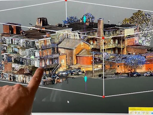
Studio registration work is aided by AI classifications and takes a fraction of the time.
This accelerates the registration phase dramatically.
Want to lean more? See whitepaper: FARO-S-150-vs.-Leica-RTC-360-vs.-Trimble-X7
“The Trimble X7 gives me far more scanning flexibility. I can scan a room in under two minutes or scan over 250-foot radius in high density. The on-site Registration Assist gives me so much more confidence that we’re leaving a site with projects ‘in the can.’ I am able to produce a registration report in the field and have it approved by our registration team in the studio before leaving the site.
”

What is Point Cloud Registration?
Scan2Plan creates BIM/CAD documentation from 3D Point Cloud data sets. All of our measurement, modeling and risk mitigation rely on these 3D data sets.
At each individual LiDAR scan location we capture a “burst” of hundreds of thousands of colorized points (XYZ coordinates).
This burst of points gets aligned with every other bust in a multi-phase process called point cloud registration.
In the field, we ensure that every burst overlaps with at least two other bursts to verify and validate point cloud location integrity.
In the studio, we are able to tighten up the point cloud with machine vision to an accuracy within millimeters. We then deliver a cleaned and unified point cloud to our BIM/CAD teams and clients.
“From import to post-production, the point cloud registration process is far more intuitive and streamlined with Trimble RealWorks. The automated tools which allow for a variety of methods to select, refine, and organize points. For instance, points can be automatically grouped by object type or filtered by color for immediate identification and visual clarity. I can produce registered deliverables faster without compromising on quality or precision.”
As Scan2Plan looks to grow our services, we’re proud that we’ve been able to reduce cost and turnaround time with no compromise in quality.
We’re not only an incredible service, we’re also technology advisors, researching and implementing the latest and greatest tech so you don’t have to.
Scan2Plan is always in a state of continuous improvement. While our process may change, our reliable BIM/CAD deliverables will always be something you can count on.