The 3D Scanning Landscape
In the fast moving field of 3D mapping for the AEC industry there are many technology categories and a mind blowing multitude of products, services and options. As we enter the mixed reality of the spatial computing era, 3D mapping is growing in AEC, but also in gaming, filmmaking, real estate, industry, urban planning, archaeology, etc.

Image developed in MidJourney
Each service and its underlying technology offer unique pros and cons. Understanding the applications and use cases of each approach is crucial for making informed decisions. This article is a roundup of the prevailing technologies followed by our reasons for why we’ve chosen #7 Terrestrial LiDAR for Scan2Plan.
1) Close-Range Photogrammetry & NeRFs
Dating back to the 19th century, photogrammetry is the extraction of three-dimensional measurements from two-dimensional data (photos). Photogrammetry algorithms interpret a z coordinate (depth) from a sequence of flat x and y coordinates. Close-range photogrammetry is suitable for capturing detailed photographic information of smaller areas. It is commonly used in applications such as heritage preservation, and forensic analysis. One of the key advantages of close-range photogrammetry is its ability to capture fine photorealistic detail. This method requires careful planning, lighting and setup to ensure optimal image quality and accuracy. Photogrammetry can be time-consuming, capturing hundreds or thousands of images from multiple viewpoints to ensure full coverage and accuracy.
NeRF (Neural Radiance Fields) & Gaussian Splats are emerging technologies with new algorithmic ways of extracting 3D data from 2D photos. The technology is similar to photogrammetry in that it's an incredible tool for immersive content but essentially useless for construction-ready dimensional accuracy.

Orthographic photogrammetry Image from Wessex Archaeology
Pros: Cost-effective, useful for creating photorealistic 3D models
Cons: Time consuming, Less accurate than LiDAR, no validation without independent measurements or methods, requires photo coverage from every angle, struggles with detailed structures
Applications: Small Scale Interior Mapping & Modeling
Use Cases: Forensic Analysis, Heritage Preservation, Immersive Journalism, Gaming/XR
Products & Services: Reality Capture, Cupix, Polycam, Luma Ai
Accuracy: ⭐️⭐️
Range: ⭐️
2) Aerial Photogrammetry
Aerial Photogrammetry uses photogrammetry principles to generate maps and models from photos taken from a drone or aircraft. It’s cost effective and covers vast areas quickly. Aerial Photogrammetry is often integrated with geo-referencing and/or LiDAR to improve accuracy. Aerial photogrammetry is affected by lighting, weather conditions and flight regulations.

Model of London derived from Aerial Photogrammetry by AccuCities
Pros:: Cost Effective, Fast, Covers Large Areas
Cons: Less accurate than LiDAR, no validation without independent measurements or methods, requires good lighting and weather conditions, may struggle with detailed structures.
Applications: Large Scale Exterior Mapping & Modeling
Use Cases: Topographic Mapping, Industrial Analysis, Building Inspections, Construction Documentation, Geology, Disaster Relief, Filmmaking, Gaming/XR
Products & Services: Drone Deploy, Skydio
Accuracy: ⭐️⭐️
Range: ⭐️⭐️⭐️⭐️⭐️
3) Structured Light
Structured light technology involves projecting a pattern of light (usually infrared) onto an object and capturing the deformations of the pattern with a camera. This allows for the creation of 3D models by analyzing how the pattern is distorted on the object's surface. Structured light scanners, such as those used in the Matterport Pro2 system, are known for their ease of use and ability to capture 3D models quickly. These scanners are popular in industries such as real estate, interior design, and virtual tours, for their ease of use for space planning. Structured light technology has limitations, including a limited range compared to LiDAR and inability to scan in direct sunlight. Structured light scanners may struggle with scanning reflective or transparent surfaces. There is no way to validate tolerances without independent measurements or methods.
Image developed in MidJourney
Pros: Easy to use, suitable for small to medium-sized spaces, good for creating immersive experiences
Cons: Less accurate than LiDAR, limited range, no validation without independent measurements or methods, Interior-only (inability to scan in direct sunlight)
Applications: Small Scale Interior Modeling & Space Planning
Use Cases: 3D Tours, Space Planning, Conceptual Documentation
Products & Services: Matterport Pro2
Accuracy: ⭐️⭐️
Range: ⭐️⭐️
4) Time of Flight (ToF) Sensors
Time of Flight (ToF) Sensors are now included in consumer appliances like iPhones, iPads and Cars. These sensors measure the time it takes for a laser pulse to travel to an object and back, similar to traditional LiDAR, but they use a different method to calculate distance. They use a single chip that collects LiDAR data at a low sampling rate (hundreds vs millions of points). Since they use a single, forward facing chip versus a kinetic omnidirectional laser array, the user needs to walk around the space with the sensor for it to understand 3D geometry. This can lead to the dreaded “banana effect”.
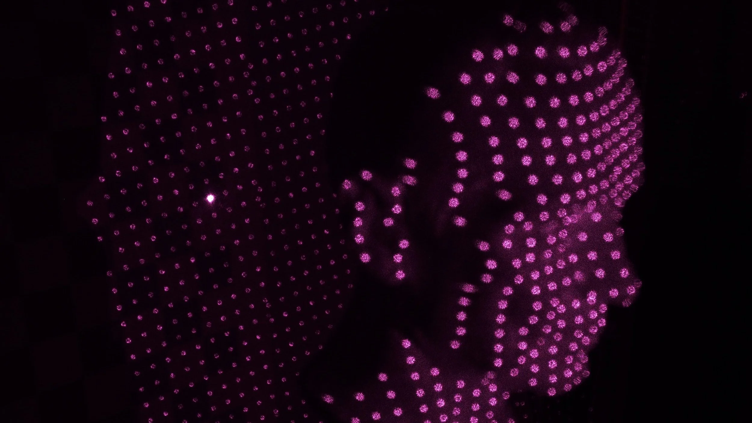
Image courtesy of Jorma Palmén
Pros: Compact size, low cost, fast results, ease of Integration
Cons: Limited range and accuracy, no validation without independent measurements or methods, not suitable for complex, detailed or large-scale projects
Applications: Small Scale Interior Modeling & Space Planning
Use Cases: Space Planning, Interior Design, Conceptual Documentation
Products & Services: Canvas, Polycam
Accuracy: ⭐️⭐️
Range: ⭐️⭐️
5) Mobile LiDAR
Mobile LiDAR captures 3D data while in motion, typically mounted on vehicles (car, drone, etc). These systems use multiple LiDAR sensors and cameras to scan and capture detailed information about the surrounding environment. Mobile LiDAR is commonly used for mapping roads, railways, catenaries, and other linear infrastructure. Mobile LiDAR reduces the time and cost associated with traditional surveying methods. Mobile LiDAR systems may have limitations in terms of accuracy and detail compared to Terrestrial LiDAR systems. The data captured by mobile LiDAR may be less precise, especially in areas with complex geometry or where high levels of detail are required. Mobile LiDAR systems are expensive to operate and maintain.
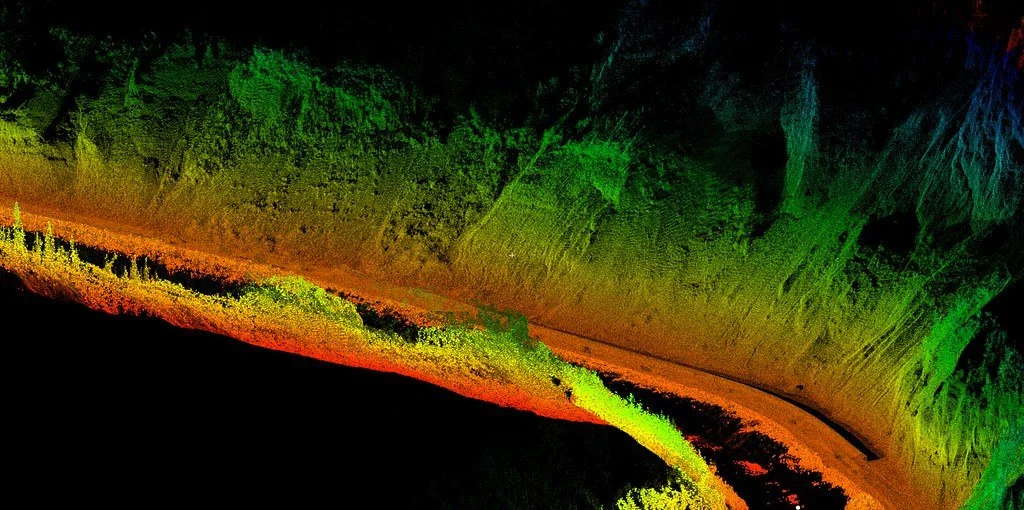
Image courtesy of Oregon State University
Pros: Fast Data Capture, suitable for capturing large areas, useful for transportation infrastructure
Cons: Expensive, no validation without independent measurements or methods, struggles with detailed architectural features
Applications: Large Scale Exterior Documentation
Use Cases: Roads, Landscapes, Infrastructure, Municipal, Roads, Caternaries
Products & Services: LiDAR USA, Routescene
Accuracy: ⭐️⭐️⭐️
Range: ⭐️⭐️⭐️⭐️⭐️
6) SLAM Scanners
SLAM (Simultaneous Localization and Mapping) Scanners are designed for large scale indoor mapping and navigation. These scanners use a combination of LiDAR, cameras, and inertial sensors to create detailed 3D maps in real-time. SLAM scanners are ideal for mapping large indoor environments, such as malls or warehouses. They are often paired with devices like a Total Station or Terrestrial LiDAR to establish control points to independently validate any “drift” in the data across large areas.

SLAM point cloud captured by Scan2Plan - see case study
Pros: Can map large indoor environments quickly
Cons: Requires additional control data for accuracy, may not be as precise as terrestrial LiDAR.
Applications: Extra large interior (over 100,000 sqft)
Use Cases: Malls, Campuses, Hotels Hospitals, Warehouses, Schematic Documentation, Construction-Ready Documentation, Historic Preservation
Products & Services: Navvis, GeoSlam
Accuracy: ⭐️⭐️⭐️⭐️
Range: ⭐️⭐️⭐️⭐️⭐️
7) Terrestrial LiDAR
Terrestrial LiDAR, also known as kinetic LiDAR, is a powerful technology used for high-precision 3D scanning. Devices such as those from Leica, Trimble and Faro capture detailed point clouds of structures and landscapes. Terrestrial LiDAR scanners emit laser pulses and measure the time it takes for the laser to return, allowing them to calculate distances with millimeter accuracy. This technology is ideal for capturing detailed architectural, structural, MEP, and civil engineering features. One of the key advantages of terrestrial LiDAR is its high level of accuracy and range, making it suitable for capturing intricate details over large areas. Terrestrial LiDAR scanners can capture millions of points per second, providing a comprehensive and detailed representation of the scanned environment. Terrestrial LiDAR scanners are expensive, complex to operate and the scanning process can be time-consuming. Terrestrial LiDAR remains the preferred choice for professionals in the AEC industry due to its unparalleled accuracy, validation, and point cloud density.

Pros: High accuracy, range and sample rate, suitable for capturing detailed architectural features, self-validating data.
Cons: Higher cost and complexity,
Applications: Small, Medium and Large buildings and structures (interior & exterior), Landscape
Use Cases: Commercial & Residential Architecture, Structural, MEP & Civil Engineering. Schematic Documentation, Construction-Ready Documentation, Historic Preservation
Products & Services: Scan2Plan
Accuracy: ⭐️⭐️⭐️⭐️⭐️
Range: ⭐️⭐️⭐️⭐️
At Scan2Plan, we have experimented with each technology listed above. This has led us to use exclusively terrestrial LiDAR for its unparalleled accuracy, density and self-validation. Our workflow is purpose built for construction-ready documentation. We aim to deliver the same level of accuracy and point cloud density on every project, which is why we rarely mix and match these technologies. Our workhorse scanner is the Trimble X7 which offers millimeter accuracy along with best-in-class software and extensibility. For extra large scale projects we are looking into using SLAM Scanners (Navvis VLX) along with control data from the Trimble X7. More about that coming soon!